|
The Gulf of Alaska arcs at its northern edge, forming the rounded northern
shore of the Pacific Ocean, a zone of great collisions. This region is where the
earth's tectonic plates collide, spewing forth froths of hot lava from dozens of
volcanoes, and fracturing and folding the earth with titanic earthquakes. Here,
the ocean's weather hits mountains jutting miles high from the sea, growing
immense prehistoric ice sheets and glaciers that carve the rock into long, deep,
intricate fjords. The sea proffers prodigious biological wealth on these shores,
including the salmon it unleashes into the rivers in furious swarms of life that
climb over the mountains and into the Interior to spawn. Nature seems giant and
superabundant along this magnificent arc of land and water.
As a region, Southcentral is
something of a catchall. The landforms in this part of Alaska are the most
varied in the the state. More than half of Alaska’s residents live
in this region of spectacular glaciers, fjords, roadside lakes, salmon streams
and ocean beaches. From the jagged Gulf of Alaska coastline, the land
rises to the Alaska Range, and Mt. McKinley, the continent's highest peak. The
Gulf Coast is generally mountainous, and is indented by massive Prince William
Sound and Cook Inlet. Inland, the land is hilly or mountainous and incised
by major rivers, including the Copper, Matanuska, Susitna, Kvichak, and
Mulchatna. The Susitna River valley, sculpted by ancient glaciers, is one of
the few with a broad floodplain.
Southcentral dominates Alaska, with a more highly developed transportation
system than anywhere else, including a network of highways and the Alaska
Railroad.
Alaskans living in the Interior sometimes call portions of this
part of the state "the banana belt" -- a little wry humor, and understandable
when comparing winters up north with this relatively moderate climate.
The ocean influences Southcentral's
weather, keeping it from being very hot or very cold while the Alaska Range of mountains forms a border
at
the north side of this region. Not only does the Range block most of the cold air from the interior,
but the mountain chain also retains warm ocean
air here.
Coastal communities are frequently as wet as
southeastern cities, but the amount of rainfall lessens considerably just a
short distance inland. Summers here tend toward cool and
moist, depending on the location. Summer temperatures range from the
50's to the 80's, with coastal temperatures being cooler than more inland
locations.
Geography endowed this region with several of the world's great
natural places. In the east, near Cordova, the Copper River's immense,
entirely unspoiled delta is the largest contiguous wetlands in the Western
Hemisphere.
The Copper River Basin lies between the Chugach and Wrangell mountains and
during the ice age was once the site of a large lake. Today it is a forested
woodland.
Cook Inlet extends north and then east from the Gulf of
Alaska. It divides into two arms: Knik Arm on the north and Turnagain Arm on the
south, with Anchorage on the peninsula between the two. Cook Inlet and its two
arms are noted for their tidal bores -
breaking waves rushing upchannel when the tide comes in. They are due to the
fact that much of the inlet is too shallow to support normal flow of water when
the tide comes in. With 30 to 35 feet between the high and low
tides, the Inlet has the second largest range in the world after the Bay of Fundy in Nova Scotia. The reason for this enormous tidal range that is the same in
Cook Inlet as in the Bay of Fundy: the length of the bay is such that the
resonant frequency of the water sloshing back and forth in it is close to 12
hours, which is the frequency at which tidal forces from the moon and sun are
driving it. Cook Inlet is the only place in North America where tidal
bores are frequently observed.
When Captain Cook explored Turnagain Arm, he
observed the tidal bores, recognized the danger, and told his crew to head back
out to sea. That's how Turnagain Arm got its name. At low tide, miles of mud flats become exposed; if it were not
for the occasional quicksand and possibility of tidal bores when the tide comes
back in, it would be safe to walk across the entire width of the channel in some
places. One would think that Turnagain Arm would be very deep because it is
surrounded by mountains. However, the heavily silt-laden glacial streams drop
their loads when they flow out into the calmer waters of the sea. Over the eons
the silt accumulates into a mud flat which is exposed at low tide.
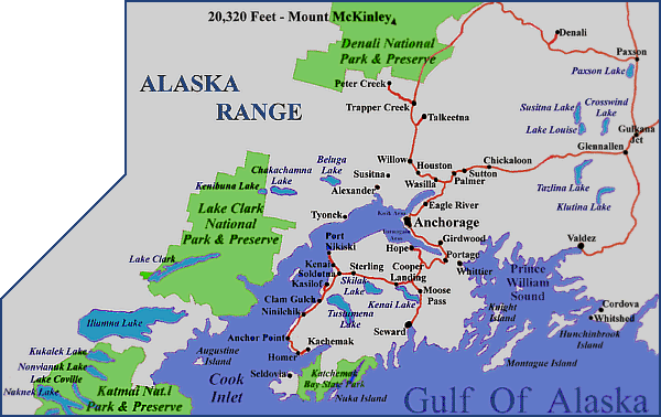 The Matanuska-Susitna
(Mat-Su) Valley
consists of fertile farmland against the majestic backdrop of the Chugach
Mountains. This
is Alaska’s only major agricultural area.
Fertile glacial soil, long summer days, and a natural watering system as frozen
ground melts, combine to produce such prize-winning vegetables as a 10 lb.
carrot, a 42 lb. beet, a bunch of broccoli tipping the scales at 35 lbs., and a
105 lb. cabbage. The state's dairy industry is also in the Mat-Su Valley. The Matanuska-Susitna
(Mat-Su) Valley
consists of fertile farmland against the majestic backdrop of the Chugach
Mountains. This
is Alaska’s only major agricultural area.
Fertile glacial soil, long summer days, and a natural watering system as frozen
ground melts, combine to produce such prize-winning vegetables as a 10 lb.
carrot, a 42 lb. beet, a bunch of broccoli tipping the scales at 35 lbs., and a
105 lb. cabbage. The state's dairy industry is also in the Mat-Su Valley.
The 15,000 square miles of Prince William Sound are full of
glacially-carved fjords over 1,000 feet deep and mountains that thrust out
of the sea to their highest point on Mt. Marcus Baker at 13,250 feet. Waters of
the Sound are protected by a series of islands which provide a protective
barrier to the ocean swells. A 3,500 mile-long coastline is the boundary to the
world's most northern temperate rain forest. Three million acres of forest are
home to western hemlock, white spruce and Sitka spruce, some of which grow to
over 100 feet tall. The communities of Whittier, Valdez
and Cordova are the gateways to the waters of the Sound. Shipping is
focused at the port of Valdez, which is the southern terminus of the
trans-Alaskan pipeline. Fishing, forestry, and some mining are prevalent
activities in the area. On March 24,
1989, the Exxon Valdez hit a reef nearby and spilled approximately 10
million gallons of oil into Prince William Sound. Clean-up efforts ensued
however, much of the region's wildlife was killed or endangered as a result of
the environmental disaster.
The immense Columbia Glacier is the second largest in Alaska.
It's a 440-square-mile river of ice flows into Columbia Bay in the north
central portion of Prince William Sound. This "tidewater" glacier emptied
directly into the ocean. The Columbia was born in the snowfields of the Chugach
Mountains and gradually meandered 23 miles beyond its ancestral fjord.
The Kenai Fjords are coastal mountain fjords whose placid
seascapes reflect scenic ice bound landscapes and whose salt spray mixes with
mountain mist. Located on the southeastern Kenai Peninsula, the national
park is a pristine and rugged land supporting many unaltered natural
environments and ecosystems. This land boasts an icefield wilderness, crowned by the 700-square-mile
Harding Icefield, one of four major ice caps in the United States. It's thought
that the icefield is a remnant of the Pleistocene ice masses once covering half of Alaska.
Along the coastline of the Kenai Fjords, steep valleys that were
carved by glaciers in retreat. Active glaciers still calve and crash into the
sea. Unnamed waterfalls in
unnamed canyons, glaciers that sweep down narrow mountain valleys, and a
coastline along which thousands of seabirds and marine mammals raise their young
each year. Sea stacks, islets, and jagged shoreline are remnants of
mountains that today inch imperceptibly into the sea under the geological force
of the North Pacific tectonic plate.
Though the land is subsiding, a mountain platform 1 mile high
still comprises the coast's backdrop. The mountains are mantled by the
300-square-mile Harding Icefield, the park's dominant feature. The icefield was
not discovered until early this century when a mapping team realized that
several coastal glaciers belonged to the same massive system. Today's icefield
measures some 35 miles long by 20 miles wide. Only isolated mountain peaks
interrupt its nearly flat, snowclad surface. These protruding nunataks - the
Eskimo word meaning "lonely peaks" - rise dramatically from the frozen clutches of
the Ice Age. Here are found newly exposed, scoured, and polished bedrock
and a regime of plant succession from the earliest pioneer plants to a mature
forest of Sitka spruce and western hemlock.
The mountains intercept moisture-laden clouds, which replenish
the icefield with 35-65 feet of snow annually. Time and the weight of overlying
snow transform the snow into ice. The pull of gravity and the weight of the
snowy overburden make the ice flow out in all directions. It is squeezed into
glaciers that creep downward like giant bulldozers, carving and gouging the
landscape. Along the coast eight glaciers reach the sea, and these tidewater
glaciers calve icebergs into the fjords. The thunderous boom of calving ice can
sometimes be heard 20 miles away.
Moose, bears, and a large population of mountain goats inhabit
this region. Steller sea lions haul out on rocky islands at the entrances to the
fjords. Harbor seals rest on icebergs. Killer whales, porpoises, sea otters, and
several whale species also are found here. Thousands of sea birds -- horned and
tufted puffins, common murres, and black-legged kittiwakes -- rear their young
on steep cliffs.
On the southern tip of the Kenai peninsula,
Kachemak Bay is like a miniature Prince William Sound, but with people. The
bay's shores are dotted with tiny towns on pilings.
Humans have had a lasting impact on this environment,
but the plants and wildlife continue to subsist here amidst dynamic
interactions of water, ice, and a glacier-carved landscape relentlessly pulled
down by the Earth’s crustal movements. The Harriman Expedition, a
steamship-borne venture visiting the fjords in 1899, predicted this area's
future value as a scenic tourist attraction. He was right.

The following communities are in the south central region:
Alexander
Anchorage
Anchor Point
Big Lake
Cantwell
Chickaloon
Chistochina
Chitina
Clam Gulch
Cooper Landing
Copper Center
Cordova
Crown Point
Eagle River
Eyak
Farewell |
Gakona
Gakona Junction
Girdwood
Glennallen
Gulkana
Halibut Cove
Homer
Hope
Houston
Iliamna
Kalifornski
Kasilof
Kenai
Knik
Lazy Mountain
McCarthy |
Meadow Lakes
Mendeltna
Mentasta Lake
Moose Pass
Newhalen
Nikiski
Ninilchik
Nondalton
Northway Junction
Palmer
Paxson
Pedro Bay
Peters Creek
Pile Bay
Port Alsworth
Seldovia
Seward |
Skwenta
Slana
Soldotna
Sterling
Sutton
Talkeetna
Tanacross
Tazlina
Tetlin Junction
Tok
Trapper Creek
Tyonek
Valdez
Wasilla
Whittier
Willow |
|