|
Paxson
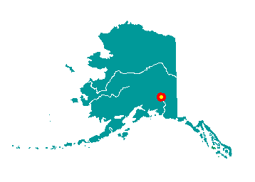
Paxson lies on Paxson Lake, at mile 185 of
the Richardson Highway, at its intersection with the Denali Highway. It
is south of Delta Junction and 62 miles north of Gulkana. It lies at
approximately 63° 02' N Latitude, 145° 29' W Longitude (Sec. 05, T022S,
R012E, Fairbanks Meridian). The community is located in the Chitina
Recording District. The area encompasses 51 sq. miles of land and 6 sq.
miles of water.
 More
than 400 archeological sites indicate that this area has been inhabited
for at least 10,000 years. In 1906 Alvin Paxson established the
Timberline Roadhouse at mile 192, which consisted of a small cabin for a
kitchen and two tents for bunkhouses. His cook, Charles Meier, later
started Meier's Roadhouse at mile 174. Paxson then built a two-story
roadhouse at mile 191. He later added a barn with a drying room, pump
and sleeping quarters, two rooms and a bath. A post office, store, wood
house and small ice room followed. More
than 400 archeological sites indicate that this area has been inhabited
for at least 10,000 years. In 1906 Alvin Paxson established the
Timberline Roadhouse at mile 192, which consisted of a small cabin for a
kitchen and two tents for bunkhouses. His cook, Charles Meier, later
started Meier's Roadhouse at mile 174. Paxson then built a two-story
roadhouse at mile 191. He later added a barn with a drying room, pump
and sleeping quarters, two rooms and a bath. A post office, store, wood
house and small ice room followed.
The Denali Highway was built in the
1950s from Paxson to Cantwell and the Denali National Park. The 160-mile
gravel road was the only access into the park prior to construction of
the George Parks Highway. The Denali Highway also provides access to the
Tangle Lakes Recreation Area, Summit Lake, and the largest active gold
mine in Alaska.
|