|
Minto
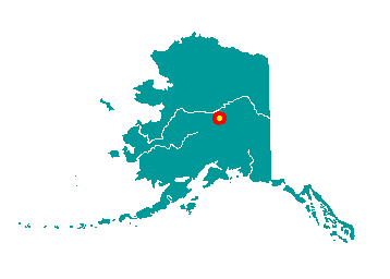
Minto is located on the west bank of the
Tolovana River, 130 miles northwest of Fairbanks. It lies on an 11-mile
spur road off of the Elliott Highway. It lies at approximately 64° 53' N
Latitude, 149° 11' W Longitude (Sec. 23, T004N, R009W, Fairbanks
Meridian). The community is located in the Manley Hot Springs Recording
District. The area encompasses 163 sq. miles of land and 4 sq. miles of
water.
 Minto
is in the western-most portion of traditional Tanana Athabascan
territory. During the late 1800s, some members of the Minto band
traveled to Tanana, Rampart and Fort Yukon to trade furs for
manufactured goods, tea and flour. With the discovery of gold north of
Fairbanks in 1902, steamboats began to navigate the Tanana River,
bringing goods and new residents into the area. Old Minto became a
permanent settlement when some members of the Minto band built log
cabins there, on the bank of the Tanana River. Other families lived in
tents on a seasonal basis. A BIA school was established in 1937, but
most families still did not live in Minto year-round until the 1950s.
The Minto band was eventually joined by families from Nenana, Toklat,
Crossjacket and Chena. The village was relocated to its present
location, 40 miles north of the old site, in 1969 due to repeated
flooding and erosion. The present site had been used as a fall and
winter camp since the early 1900s. New housing and a new school were
completed by 1971. Minto
is in the western-most portion of traditional Tanana Athabascan
territory. During the late 1800s, some members of the Minto band
traveled to Tanana, Rampart and Fort Yukon to trade furs for
manufactured goods, tea and flour. With the discovery of gold north of
Fairbanks in 1902, steamboats began to navigate the Tanana River,
bringing goods and new residents into the area. Old Minto became a
permanent settlement when some members of the Minto band built log
cabins there, on the bank of the Tanana River. Other families lived in
tents on a seasonal basis. A BIA school was established in 1937, but
most families still did not live in Minto year-round until the 1950s.
The Minto band was eventually joined by families from Nenana, Toklat,
Crossjacket and Chena. The village was relocated to its present
location, 40 miles north of the old site, in 1969 due to repeated
flooding and erosion. The present site had been used as a fall and
winter camp since the early 1900s. New housing and a new school were
completed by 1971.
|