|
Koyuk
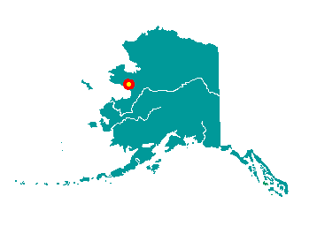
Koyuk is located at the mouth of the Koyuk
River, at the northeastern end of Norton Bay on the Seward Peninsula, 90
air miles northeast of Nome. It lies at approximately 64° 56' N
Latitude, 161° 09' W Longitude (Sec. 32, T006S, R012W, Kateel River
Meridian). The community is located in the Cape Nome Recording District.
The area encompasses 5 sq. miles of land and 0 sq. miles of water.
 The
site of "Iyatayet" on Cape Denbigh to the south has traces of early man
that are 6,000 to 8,000 years old. The villagers were historically
nomadic. Lt. Zagoskin of the Russian Navy noted the village of "Kuynkhak-miut"
here in 1842-44. A Western Union Telegraph expedition in 1865 found the
village of "Konyukmute." Around 1900, the present townsite began to be
populated, where supplies could easily be lightered to shore. Two boom
towns grew up in the Koyuk region around 1914: Dime Landing and Haycock.
The "Norton Bay Station," 40 miles upriver, was established to supply
miners and residents in 1915. In addition to gold, coal was mined a mile
upriver to supply steam ships and for export to Nome. The first school
began in the church in 1915; the U.S. government built a school in Koyuk
in 1928. The
site of "Iyatayet" on Cape Denbigh to the south has traces of early man
that are 6,000 to 8,000 years old. The villagers were historically
nomadic. Lt. Zagoskin of the Russian Navy noted the village of "Kuynkhak-miut"
here in 1842-44. A Western Union Telegraph expedition in 1865 found the
village of "Konyukmute." Around 1900, the present townsite began to be
populated, where supplies could easily be lightered to shore. Two boom
towns grew up in the Koyuk region around 1914: Dime Landing and Haycock.
The "Norton Bay Station," 40 miles upriver, was established to supply
miners and residents in 1915. In addition to gold, coal was mined a mile
upriver to supply steam ships and for export to Nome. The first school
began in the church in 1915; the U.S. government built a school in Koyuk
in 1928.
|